How to convert SHP to DWG (or SHP to DXF):

Step 1: Select a Shapefile.

Shp to Dwg/Dxf Converter -file selection

Step 2: If necessary, also select Features Attributes, Text Labels, or Elevation. Press the Specify button.

Select feature attributes, Text Labels, Legend or Elevation

Step 3: Select Feature Attribute Fields that you want to convert. Then press the "-->" button and the OK button.

Select attributes that you want to convert

Step 4: Press the Save button. Then Arcv2CAD converts the shapefile to a DWG file.

Press save button to convert Shp to DWG

Our software clients:


Software Overview:

Click to enlarge Arcv2CAD software screenshot images

Extrude 2D polygon shapefile to AutoCAD 3D objects
Extrude 2d Polygon to 3D objects - Arcv2CAD


Convert elevation [contour] data as real 3D Z coordinates
Output elevation data as a real 3D z cordinates - Arcv2CAD

Apply Colors corresponding to selected Feature Attributes and convert to AutoCAD text annotations.
Apply colors to corresponding feature attributes - Arcv2CAD

Transfer table data via DXF/DWG ATTRIB or Extended Data (XData) definitions.
transfer table data - Arcv2CAD


You can easily keep attributes when converting ESRI ArcGIS Shapefile to DXF/DWG.

converting Shapefile attributes to DWG
You just need to tick "Features Attributes", press Specify button and select attributes you want to convert to DXF/DWG.


Support Windows OS: Win 2008/2012/Citrix/
Win7/win7x64/Win8/Win8x64/Win10/Woin11


Client Testimonials

Your Feature Complete Solution!


Conversions:

 • Translate to AutoCAD DXF and DWG versions up to AutoCAD 2018-2024
 • Optionally output to CSV.
 • Command line mode for batch operation.

Handling feature attributes:

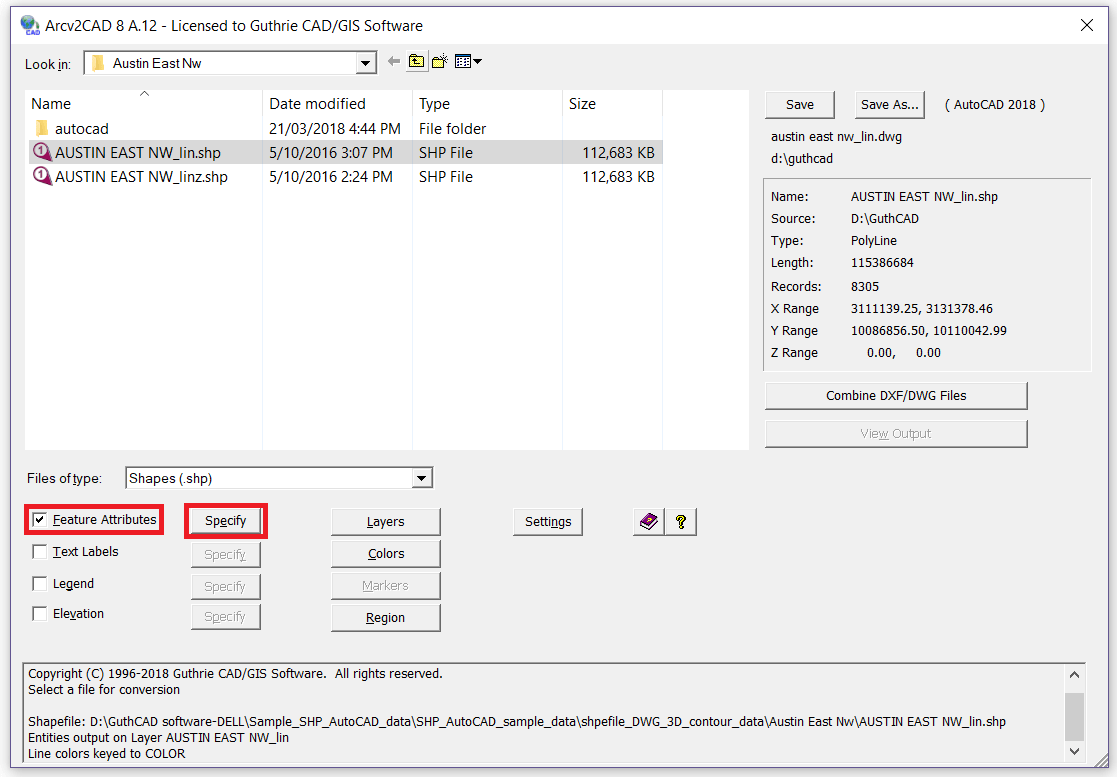
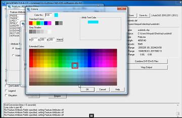
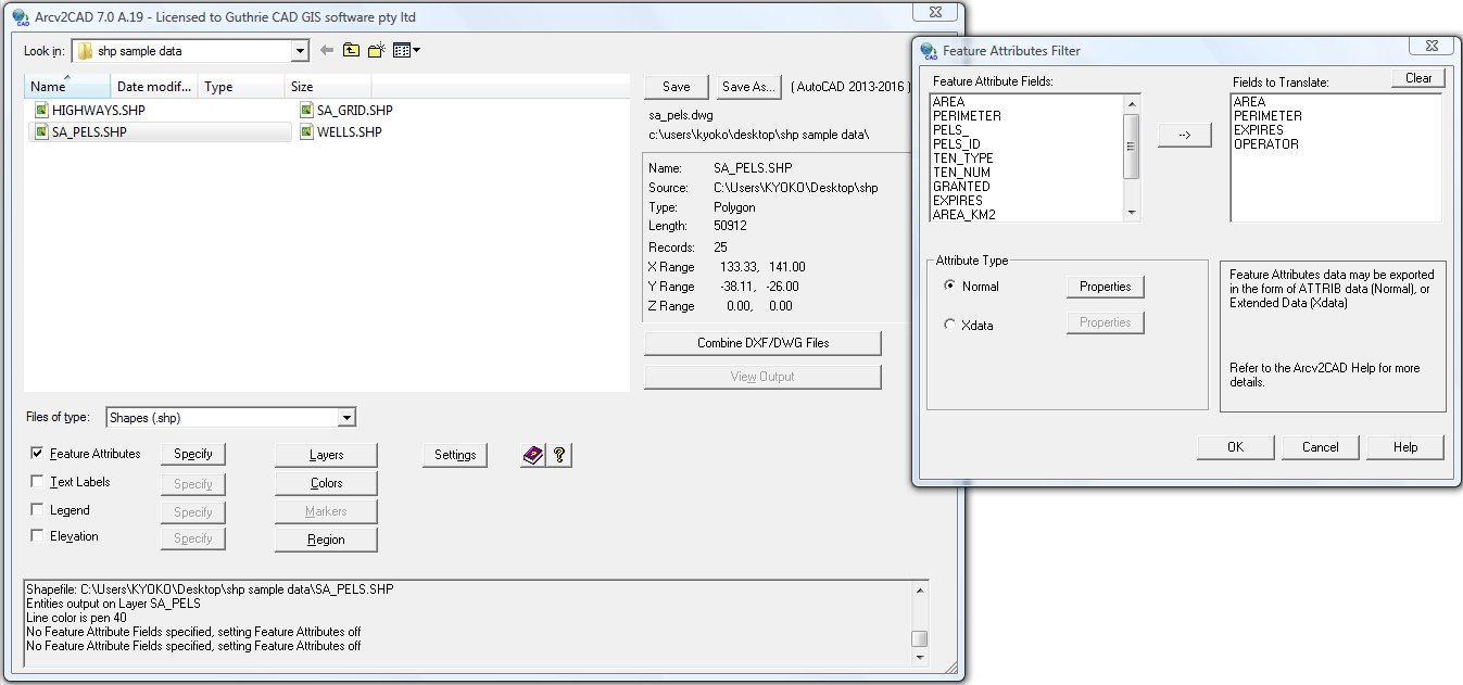
 • Apply Colors corresponding to selected Feature Attributes.
 • Output AutoCAD entities onto Layers corresponding to Feature Attributes.
 • Produce Text Labels from Features data. Powerful built in Auto-Label function.
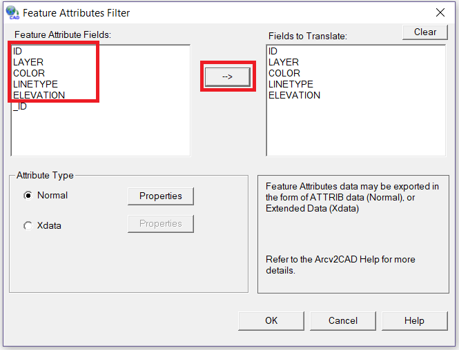
 • Transfer table data via DXF/DWG ATTRIB or Extended Data (XData) definitions.

Layer and properties control:

 • Properties control for attributes (ATTRIBs), i.e. size, position, color, etc.
 • Layer control - The Layers Control dialog allows you to determine LAYER names, and the entities that will be placed on such Layers.

3D shapefile type:

 • Support for all 3D shapefile types (PointZ, PolylineZ, PolyGonZ, MultiPatch, etc).
 • Fully handles the latest 3D shapefiles.

Handling polygon shapefile:

 • Extrude 2D Polygon shapes to 3D Objects in DWG/DXF.
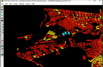
 • Color fill Polygons - correctly handles holes.

Data Source:

 • Compatible with all ESRI ArcGIS® / ArcMap®/ ArcView® / ... software (all versions.).
 • Support direct access to shapefiles in ESRI Personal Geodatabase (.mdb) files.operation.
 • Data source may be CSV or DBF (i.e. no shapefile, simply a points database).

Handling elevation data (Z values):

 • Output Elevation data as real 3D Z coordinates.
 • Create elevation labels from point Z shapefile's Z values.

Legend and Named Marker Blocks:

 • Output of a Legend
 • Named Marker Blocks


Pricings & Plans

FREE TRIAL

FREE

for 15 days

The evaluation version of Arcv2CAD is enabled for 15 days. The trial version is converted to the full version once the software is registered.

DOWNLOAD NOW


Standard License

149

per user

Buy a standard license. Prices start from $149 USD. You can see details of the price structure from here.

ORDER NOW


Network License

450

per number of concurrent user

Buy a network license. Prices start from $450 USD. You can see details of the price structure from here.

ORDER NOW